
Bleeding Heart Still Beating Lifeblood, 2023
Burn marks, cochineal, and thread on canvas hanging between reclaimed wood
50.5” x 32” x 2”
Bleeding Heart Still Beating Lifeblood is a reorientation of geographies, approached from West to East; from the Pacific Ocean, to the Gulf of Mexico, to the Atlantic Ocean; from where the Sun sets to where it rises; from bottom-up. This work centers the Gulf of Mexico as an entry/exit way, key to manifold past, present, and future mass movements and global uprisings, both human-made and more-than-human-made. It points to the directionality of navigable paths as apex to retracing and identifying that which has taken shape as care for/harm of lands, bodies, and cultures between wind and wave. More specifically, Bleeding Heart Still Beating Lifeblood spotlights the vastness in forms of exchange rooted in resistance and resilience and strengthened by a cyclical resurgence of power in relationality.
Select features of interest include: Pacific Ocean, Gulf of Mexico, Atlantic Ocean, Great Continental Divide, Eastern Continental Divide, Paricutin Volcano, Chicxulub Crater, Door Point Volcano (an extinct volcano located offshore in St. Bernard Parish, Louisiana “discovered” by Shell Oil Company), Rio Grande River, Usumacinta River, Mississippi River, and Port of Veracruz.

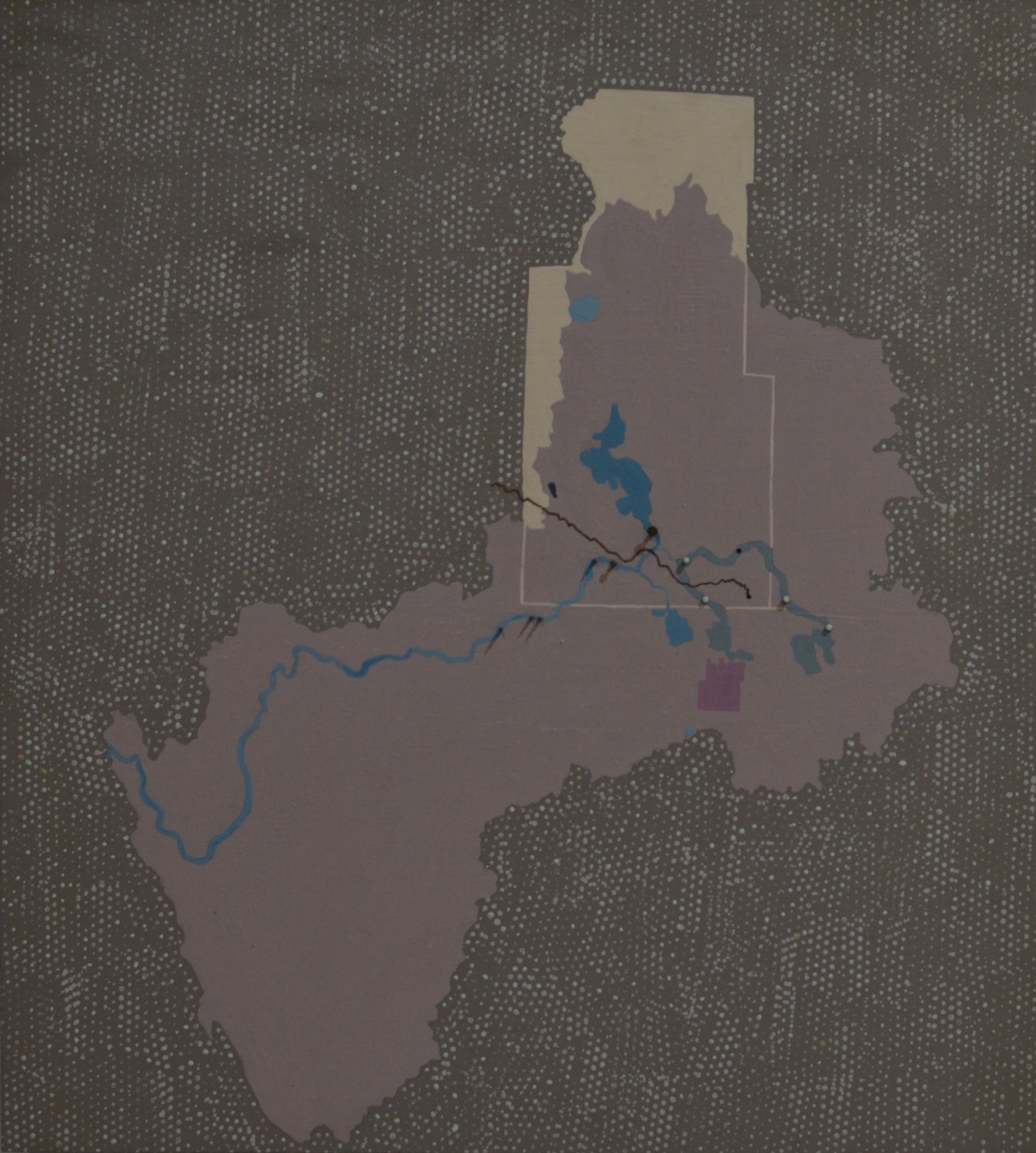
Helium in Hugoton Field, 2020
Acrylic, thread, on canvas
16” x 14”

End of the World, 2020
Found nurdles, found shell, on found wood
9.5” x 15.5” x 1”

The Klamath River, 2020
Acrylic, found nails, on wood panel
18” x 16” x 2”
The Klamath Basin, 2020
Acrylic, found nails, on wood panel
18” x 16'“ x 2”

Fools Gold, 2020
Acrylic, gold leaf, on canvas
12” x 12”

Pinky in Calcasieu Lake, 2019
Acrylic and oil pastels on canvas
12” x 9”

Wild Beast, 2019
Hemp cord, “silkine” thread, brass eyelets, gold leaf on plastic in found wood
63.5” x 63.5” x 2.5”

Those who dwell in the Waters, 2019
Acrylic, latex house paint, gel medium on canvas
63” x 63”
Those who dwell in the Waters is an overlay of numerous sourced maps, dating back hundreds of years to present day. Select traits are both physical and abstract, depicting the complexity of place and time.
Characteristics represented (in no particular order) include but are not limited to: The Louisiana Purchase, The Mississippi/Atchafalaya River Basin (MARB) specifically Mississippi (on a list of most polluted), Missouri, Yellowstone, Platte, Arkansas, Red, Atchafalaya, Wisconsin, Illinois, Ohio (on a list of most polluted), and Tennessee (on a list of most polluted) Rivers, The Lewis and Clark Trail (St. Louis, MS-mouth of Columbia River in OR ), The Zebulon Pike Trail (St. Louis, MS- “explorers” spent time in Mexico as captives then were returned to Natchitoches, LA), The Trail of Tears by Land and Water, The Oregon Trail, Transcontinental Railroad (the slaughter of buffalo), The Continental Divide of North America, The Ozarks specifically Eureka Springs ( healing waters-indigeneity as commodity, Ozarka and Nestle), Indian Territory Boundaries (Indian Removal Act) specifically the reservations of The Choctaw (first of the five great southern tribes to be moved to OK) , The Modoc (Modoc war and POW), and The Osage (oil, murders, and the FBI), The Osage ancestral lands (Osage Domain Pre-1670-1825, Osage Land 1825-1872, Osage reservation 1872-Present), No Mans Land, Mid-continent oil province (Mid-continent oil field), Shale “plays”, The Great River Road through Louisiana (plantations-cancer alley) specifically the city of New Orleans (slave trade), St. John the Baptist parish, St. James parish, and the city of Baton Rouge, Mobile AL (Clotilda-last American slave ship and slave trade), Sioux Fort Laramie Treaty Lands, Standing Rock Sioux reservation and tribal protest sites (burial and sacred sites), Dakota Access Pipeline (Stanley, ND-Patoka, ILL) Trunkline Pipeline ( Pakota, ILL-Nederland, TX), Bayou Bridge Pipeline (Nederland, TX-Lake Charles, LA-St. James), The Chitimacha ancestral lands and reservation, Midwestern states which have recently been experiencing major floods and their capital cities specifically Oklahoma City, OK, Little Rock, AR, Topeka, KS, Jefferson City, MO, Lincoln, NE, Des Moines IA, Pierre, SD

The Ozarks, 2019
Acrylic, latex house paint, charcoal, found nails on wood panel
24” x 48” x 3”

The Buffalo River Watershed, 2019
Acrylic, latex house paint, found nails on wood panel
24” x 48” x 3”

The Fayetteville, 2019
Acrylic, latex house paint, charcoal, found nails on wood panel
24” x 48” x 3”

Concerning Coal Ash: Utility Industry Sites of Significance, 2018
Acrylic latex, charcoal, black sand, screw, nails on wood panel
40” x 70” x 2”
Concerning Coal Ash: Utility Industry Sites of Significance is a study on Virginia and the relationship between the proximity of bodies of water to coal ash sites and how these concerning areas of interest specifically relate to three utility industrys’: Dominion Energy, Appalachian Power, and Duke Energy.

Fields of Filth, 2018
Acrylic latex, charcoal, nails on wood panel
12” x 12” x 2.5”
By highlighting specific counties in North Carolina, Fields of Filth brings attention to environmental racism in areas where the state’s industrial hog operations disproportionately affect lower-income, largely African American, Hispanic, and Native American peoples.

Long River, 2018
Acrylic latex, charcoal, nails on wood panel
18” x 15” x 2”

The Tuscaloosa Marine Shale, 2017
Acrylic latex, gouache, charcoal, nails on wood panel
14” x 20” x 2.5”

A Study on Helis Oil & Gas, 2017
Oil, nails on wood panel
13" x 18" x 2”